Business or casual laptop power users, get your laptop road ready.
If you need to work while on the road or just can't live without the laptop here are some tips and essential laptop gear to put on your "Go" list:
WiFi hotspots have grown remarkably over the last couple of years. You'll find that on the road most coffee shops, even in out of the way places, many rest areas, service areas and most hotels and motels offer wifi. Sometimes free of charge, sometimes not. Both WiFiFreeSpot.com and Wi-FiHotSpotList provide impressive databases of hotspots by state and city. You can help out the cause, too, by correcting or verifying wifi access on the sites. For example, find a so-called hotspot that no longer exists or charges a fee and you can easily provide site feedback for travelers behind you. No annoying login to provide feedback or to suggest a new wifi location.
Don't leave home without all your laptop gear, especially power cords. Take along a jump or flash drive for small backups or a larger external hard-drive if you have big-time critical data backups to manage.
It's a good idea to carry a short piece of Ethernet cable. Stay in accommodations that only offer high speed internet over cable and you may need it. Most places provide a network cable, some charge you for one and some don't provide them at all. Also realize that if you're relying on other's internet service you may have to ante up a small fee for access. Of course you can always opt for subscribing to your own broadband wireless service and using a wireless card or USB card. I finally tired of relying on other's Internet service and wanted to assure that I had a reliable Internet connection anywhere I have a phone signal, so I bought a Sierra Wireless Aircard a few months back. Now I have no worries. I can pull over onto the side of the road in the middle of Iowa if I need to and reliably logon to my laptop and the Internet.
Conserve battery power when you're away from a power source: I use a MacBook and I've found a shocking difference between battery life when I'm using a couple of different applications, versus using one low demand app like Word. If I am working on Word I can buy a lot more battery juice when I shut down Internet access and all other apps, as well as shut off my Airport and Bluetooth.
Or, purchase extra external power: You may also opt to purchase an external laptop battery or portable power battery, which can give you an extra jolt of juice on the road just when you need it.
The office is no longer a cubicle in some mundane beige building--it's out there anywhere you want to make it.
Wednesday, February 27, 2008
Tuesday, February 26, 2008
Gotta Have a Road Diary -- Keep it Simple, Get it Done
When you hit the road for a serious roadtrip I guarantee you will forget much of what wowed you. How do you lock in those moments of awe, the wide open spaces, the mountains, the girl you met in the ski lodge, your impressions of the city that just rose up like teeth out of nowhere?
Diary, journal, "ship's log." I have driven back and forth across the U.S. and as much as I was absolutely blown away by it all, the fact is I have lost a lot of it because of a huge gap in my travel log, a long lapse in my road trip diary because I thought I wouldn't need it. At the time I didn't know I'd crave my stupid scrawlings on notebook paper. But the truth is I have the first leg of the trip well documented and it's served me well. The second leg, the way back from Cali to the East Coast, I've had to scramble to go back and piece bits of memories together, pore over the road map for towns and highways that jog my memory. Fortunately my travel nurse companion is an avid photographer and thanks to her encyclopedic photos of the trip I have been blessed with the images that allow me to piece most of the "lost" journey together.
You don't have to spend a lot of money on some leather-bound journal to keep a travel diary. Buy a 2 buck spiral ring notebook and stow a handful of cheap pens and pencils in the vehicle's glove box. If you're not much of a photographer stop along the way and buy some postcards--you'll find postcards in almost any gas station, in full-service rest areas and tourist info stops usually well-marked and not far off the main highway.
Write what you see, the place you picked up coffee on a chilly morning, the plants and animals, new people you meet, gas prices, restaurant food, pick up a few leaves or flower blossoms and press them in among the pages, etc..
Don't lose your roadtrip by trying to commit to memory. Travel diary is a must.
Monday, February 25, 2008
Road Trip South Dakota -- My Best Kept Secret
Driving South Dakota – Mustang Ranches, Hoodoos, and Geologic Monoliths
I really have a thing against those headline articles entitled "X, A Best Kept Secret" because, duh, now it's no longer a best kept secret and who the hell would want to go there with the throngs of newbies hatched from that high profile article? So why did I name a SD roadtrip a best kept secret? Number one--it is still a minority that will actually have the gusto to take on the long-distance tar--if you do, kudos and may the road rise to meet you, you'll not be disappointed. And South Dakota is one of those states that many Americans could say, "Now where is South Dakota again? It's up near the Great Lakes or near California, isn't it?" It truly is a best kept secret. Here's my impression of southern South Dakota if I can inspire you to secretly getaway from it all...
South Dakota for me was an unexpected surprise and cacophony of variations. One minute there was epic expanse of waning sunflowers-- acres and acres of them as far as I could see-- then just as suddenly leagues of open range, the color and texture of suede; beyond those were pockets of mustang ranches.
Alongside I-90, at mile marker 139, over some no-name hillock the earth splits in an open crevice, then a few small crevasses, very subtle at first, if open gashes in the surface of a skin could be considered subtle. Each chasm is that much more significant,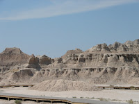 leftovers from a violent and ancient cleaving with each passing mile. Just past Kadoka, SD, route 240 marks the head of Badlands Scenic Loop. A few hours later into our trip the Badlands had become almost too much of the same thing; high, wind-carved cathedrals the color of bone. Voracious wind-- if we had stood in one spot long enough we would have been ground down, ourselves; chewed and striated by the hot harsh wind that probably killed cowboys once upon a time.
In one particular spot the limestone is the color of pink cotton candy, in another the color of a bright banana peel; the ancient sediment spun with geologic anomalies. We munched a buffalo hotdog on our drive out of the canyons.
From Badlands to Black Hills
And just as suddenly as we were overtaken by the strange Badlands, we were overcome by Black Hills. The South Dakota Black Hills are home to log cabins and cheap beef dinners. The area is thankfully unpretentious, comfortable in the visual riches they have to offer and not at all disposed to waging commercial competition for attention.
We avoided the pricey fee for going all the way into Crazy Horse, we took pictures from the road. The carving is immense, much bigger than the President’s heads on Mount Rushmore. The park fee goes toward supporting the epic carving project, but we were pretty wrung out on sight-seeing funds by the time we made it to this point. If you are interested in the history, pay the park fee and enjoy the interpretive center, otherwise there are good photo opps just outside the park gates.
South of Crazy Horse, outside Custer, SD we rented a small one-room log cabin. Owned and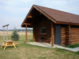 operated by a log home construction company the cabin was outfitted with all the modern conveniences. It cost us just over $100 for the night, less than a decent hotel and it was loaded with character, not to mention the perfect ambience in which to experience the South Dakota wilderness. If we had had more time we would have stayed longer and used the outdoor fire ring and fishing hole and spent an evening taking in the light show of a wide open night sky.
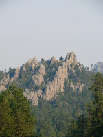 Our best driving tip of the trip was for Needles Scenic drive- a two to three hour drive through the best hidden twists and turns of the Black Hills. The drive, we cut it short by taking a short cut, really offers the best views of notable Black Hills peaks: Cathedral Spires and the Needles, both dramatic upright spikes of granite that scream ancient earth movement, looking thrust upright in a violent once-upon-a-time collision of tectonic plates or glacial tsunami. You can find Needles Drive not far from Crazy Horse. Follow routes 16A and 87. If you have a detailed map you can also cut the drive short if you need to; we did.
Our other “best of” recommendation was the dinner tip. In little downtown Hill City, just north of Custer, the Alpine Inn delivers a rare specialty: filet mignon dinner with all the trappings for $9.95 (no, not a typo). You can choose a smaller filet for $7.95, but we were hungry and totally taking advantage of the opportunity. Our total bill (for two) came to just under $30 and that with a glass of wine each added to the special. Do not expect options. This is the meal they serve every night, all year long.
Head West, young woman and man.
I really have a thing against those headline articles entitled "X, A Best Kept Secret" because, duh, now it's no longer a best kept secret and who the hell would want to go there with the throngs of newbies hatched from that high profile article? So why did I name a SD roadtrip a best kept secret? Number one--it is still a minority that will actually have the gusto to take on the long-distance tar--if you do, kudos and may the road rise to meet you, you'll not be disappointed. And South Dakota is one of those states that many Americans could say, "Now where is South Dakota again? It's up near the Great Lakes or near California, isn't it?" It truly is a best kept secret. Here's my impression of southern South Dakota if I can inspire you to secretly getaway from it all...
South Dakota for me was an unexpected surprise and cacophony of variations. One minute there was epic expanse of waning sunflowers-- acres and acres of them as far as I could see-- then just as suddenly leagues of open range, the color and texture of suede; beyond those were pockets of mustang ranches.
Alongside I-90, at mile marker 139, over some no-name hillock the earth splits in an open crevice, then a few small crevasses, very subtle at first, if open gashes in the surface of a skin could be considered subtle. Each chasm is that much more significant,
 leftovers from a violent and ancient cleaving with each passing mile. Just past Kadoka, SD, route 240 marks the head of Badlands Scenic Loop. A few hours later into our trip the Badlands had become almost too much of the same thing; high, wind-carved cathedrals the color of bone. Voracious wind-- if we had stood in one spot long enough we would have been ground down, ourselves; chewed and striated by the hot harsh wind that probably killed cowboys once upon a time.
In one particular spot the limestone is the color of pink cotton candy, in another the color of a bright banana peel; the ancient sediment spun with geologic anomalies. We munched a buffalo hotdog on our drive out of the canyons.
From Badlands to Black Hills
And just as suddenly as we were overtaken by the strange Badlands, we were overcome by Black Hills. The South Dakota Black Hills are home to log cabins and cheap beef dinners. The area is thankfully unpretentious, comfortable in the visual riches they have to offer and not at all disposed to waging commercial competition for attention.
We avoided the pricey fee for going all the way into Crazy Horse, we took pictures from the road. The carving is immense, much bigger than the President’s heads on Mount Rushmore. The park fee goes toward supporting the epic carving project, but we were pretty wrung out on sight-seeing funds by the time we made it to this point. If you are interested in the history, pay the park fee and enjoy the interpretive center, otherwise there are good photo opps just outside the park gates.
South of Crazy Horse, outside Custer, SD we rented a small one-room log cabin. Owned and
 operated by a log home construction company the cabin was outfitted with all the modern conveniences. It cost us just over $100 for the night, less than a decent hotel and it was loaded with character, not to mention the perfect ambience in which to experience the South Dakota wilderness. If we had had more time we would have stayed longer and used the outdoor fire ring and fishing hole and spent an evening taking in the light show of a wide open night sky.
 Our best driving tip of the trip was for Needles Scenic drive- a two to three hour drive through the best hidden twists and turns of the Black Hills. The drive, we cut it short by taking a short cut, really offers the best views of notable Black Hills peaks: Cathedral Spires and the Needles, both dramatic upright spikes of granite that scream ancient earth movement, looking thrust upright in a violent once-upon-a-time collision of tectonic plates or glacial tsunami. You can find Needles Drive not far from Crazy Horse. Follow routes 16A and 87. If you have a detailed map you can also cut the drive short if you need to; we did.
Our other “best of” recommendation was the dinner tip. In little downtown Hill City, just north of Custer, the Alpine Inn delivers a rare specialty: filet mignon dinner with all the trappings for $9.95 (no, not a typo). You can choose a smaller filet for $7.95, but we were hungry and totally taking advantage of the opportunity. Our total bill (for two) came to just under $30 and that with a glass of wine each added to the special. Do not expect options. This is the meal they serve every night, all year long.
Head West, young woman and man.
Thursday, February 21, 2008
Driving I-95 from Richmond to New York and Boston
Interstate 95 along the eastern corridor, particularly that stretch of tar between Richmond Virginia and Boston (the Megalopolis), has earned a reputation as a treacherous drive. Despite its teeth, millions of travelers hit this roadway everyday. I've been among them at various times of the year over the last 15 years. I've tackled 95 during rain and snow, during daylight hours, during nighttime, summer, winter, spring and fall, and holidays, weekends and weekdays.
I've found the absolute best time to challenge I-95 between Richmond and New York City, either north or southbound, is during the middle of the night. Again after years of being stung by traffic jams, bottlenecks and absurd congestion I far prefer this alternative. Nighttime driving along 95 is no desolate drive, you'll be surprised how many travelers opt for this time of day to make the pilgrimage north or south along infamous I-95. Rest areas are well lit and travelers are moving about.
Rest Areas and Full Service Travel Centers: In Maryland (Chesapeake House and Maryland House) and along the Jersey Turnpike the service centers are open, though many of the restaurants in them shut down around midnight. Although I was surprised this past Christmas to find a Starbucks open in a New Jersey travel center. Apparently they do this on the weekends--stay open later possibly even all night. You'll even find that many of the full service tourist centers have added WiFi services, so if you need to log on to your laptop you'll have little problem finding a hotspot.
You'll find that the major metro regions -- Baltimore and DC I'm thinking of particularly-- provide beltways around the areas and once upon a time I would have opted to drive those, but in recent years I've discovered that I have less traffic jams when I just follow I-95 signs straight through. In Baltimore this means you follow the highway through the Fort McHenry Tunnel that literally puts you underneath Baltimore Harbor. In New York City straight along I-95 carries you up and over the George Washington Bridge. Traveling southbound you'll get a view of the NYC skyline if you glance to your left; northbound you'll glance right. Beware: I've nearly be sideswiped taking in the skyline at night with a carefree glance. I reiterate: there is still a significant traffic volume through the major metro areas even at midnight and later.
How to drive on I-95: When you hit New York City and New Jersey yu better be alert and ready to drive with a mix of defensiveness and aggressiveness. Especially passing through NYC I-95 lanes are narrow and rough, concrete barriers allow little leeway for mistakes and you pass literally up underneath the city, lots of very tight, dark and rutted underpasses and drivers are confident and even aggressive--you must be a sure-footed driver. I actually consider this type of driving not unlike a sporting event--long-distance driving is not to be taken lightly and you really msut be mentally and physically prepared. Sound silly? Not if you've ever done this drive alone and in the middle of night. I've been nearly purposely run off the road by a trucker, I've seen a car in front of me have a major tire blow, I've been a passenger when a flatbed truck lost a stack of huge tires into our travel lane, and I've seen a car come sailing over a concrete barrier from opposing lanes and land behind me in oncoming traffic. Be alert and ready for anything.
Tolls: This stretch of I-95 is dotted with tolls. Northbound travelers pay more than southbound--no charge for GWBridge southbound. I think my latest calculations put a northbound toll total at around $27 between Richmond and NYC, so make sure you have cash. Frequent travelers along this route have E-Z Passes and you'll have to pay extra attention when coming up on the toll centers--some lanes are reserved for E-Z Pass holders only and do not take cash--so look for cash or combo lanes. And pay close attention to the traffic merges when coming out of the booths--where lanes have expanded for tolls they do the inverse--you'll lose lanes quickly and discover you merge with really fast moving traffic really quickly if you're not watching the road ahead.
Resources for Driving I-95:
Outside of a good road map a few other relevant resources include the NJ Turnpike Authority. The Visitors section of the NJTA website provides maps, traffic conditions and locations for service centers.
The Maryland Dept of Transportation website is ugly and not user-friendly so I'm not linking to it--useless unless you'd like to pick through PDF files and miniscule font. This needs a serious update!
Virginia DOT provides a pretty good index of links to a wide range of travel info that may help getting along the I-95 corridor in VA.
happy trails.
Buy a Road Map that Works
In the beginning there were no maps. Explorers set out to survey, sketch, and otherwise render their world. But we no longer have to set out with compass and survey equipment and pack animals. I criss-crossed the U.S. by car in 2007 with a travel nurse and a cat. Our most critical travel item was our road map. It is not one of those dinky ones, no abridged version. It features big pages full of state maps and accompanying pages with blow-ups of major metro areas (a critical feature). It also highlights national and state parks and makes a pretty accurate attempt to even show the actual exit numbers on the major highways.
For a road map with all that plus- you should shop for the ones that offer abbreviated state guides, trivia, and especially interesting the lists of must-see sites and places to eat in each state.
For a road map with all that plus- you should shop for the ones that offer abbreviated state guides, trivia, and especially interesting the lists of must-see sites and places to eat in each state.
Subscribe to:
Posts (Atom)


