Showing posts with label road trip. Show all posts

Monday, February 1, 2010

Gas Price Locators and Gas Cost Calculators


Find out how much it's going to set you back a buck before you set out on a roadtrip. A number of sites propose they have the best insider info on the price of gas by geographics. Here's a quick review:

GasBuddy.com rises to the top in the Google search results for geo-local gas prices. The main site is alright if you stick to the gas price heat map (quite a functional and visual tool), the gas price map, and the gas price index. However, drill deeper by states and you end up diving down a rabbit hole not far from my definition of a link farm.

AAA's Fuel Gauge Report boasts "The most comprehensive nationwide fuel price survey available from any source." According to the site over 100,000 gas stations are polled daily to cull the data on this site which includes: Daily State Gas Price Averages by State laid out in a map format and the National Average Gas Prices laid out in table format. Very user friendly in true AAA form.

MSN Autos offers a new online Interactive Gas Center in a beta map version you can opt into test driving. This is pretty slick--enter a city and state and you'll get in return a detailed map with map points and in the left-hand margin a listing of gas prices by station/brand (ie. Citgo, Gulf, BP) mapped to those plot points. Plus a fuel cost calculator.

Mapquest Gas Prices is yet another interactive map, of course using the Mapquest functionality. Search gas prices by entering addresses in the map search fields and then get a map with plot points and current prices. Also gives you a simple national high and low. Another nifty gas calculator tool.

GasPriceWatch.com is another interactive map featuring gas prices provided by unofficial gas spotters. This site's disclaimer in the tiny print at the bottom of the page is that is will not be held accountable for false information. I like the fact that the site also provides a gasoline ticker marquee across the top of the page despite the fact that I don't think the general public cares about the the price of gasoline futures.

FuelEconomy.gov, a "joint effort" of the U.S. Energy Dept and the EPA, also gets in on the gas price act with its data tools and slew of information resources. A basic interactive map, tons of educational resources, FAQs, methodology, and gas mileage tips are all included.

Thursday, May 14, 2009

Driving Boston to P-Town

Drove out of Boston yesterday morning under a perfect sky. Our plan to head to Provincetown and possibly Martha's Vinyard. From the Liberty Hotel we headed east on I-93 then picked up route 3 south and east toward Cape Cod. From Boston to P-Town is probably 2 to 2.5 hours and likely much more in the high peak season.

I have to say this is the perfect week to hit Cape Cod and P-Town. From route 3 we picked up route 6 east once over the bridge on the Cape. Our first stop was Plymouth where we checked out the Mayflower and Plymouth Rock. Again, perfect weather and only a few people there with us. Cute town and you could easily spend a day even a weekend explorign this particular area alone.
My Bad Lunch Review

We pulled off the road in S. Yarmouth to the Fat Cats deli for sandwiches--we were starving. Very disappointed here. Maybe under normal circumstances this small hometown deli can handle the lunch traffic, but not on this particular day. We ordered 3 cold deli sandwiches: 1 turkey on sourdough, one turkey/ham on sourdough, and one veggie on sourdough. We waited over 45 MINUTES while many lunch orders came and went (this joint clearly caters to the fire dept., police dept, and has a slew of regulars) while ours continued to be delayed. I'm not sure really what the problem was and suspect a few things were going on: regular cook was injured so she had others helping her, but clearly the regulars were getting their orders before us. AND it's not that they can even claim they lost our order or forgot about us. They apologized over the counter a few times for the delay, yet continued to screw us with it...so we finally asked for the money back, cancelled the order and then headed up the road to Wendy's (really pissed me off). My recommendation: don't stop here.

Route 6 through the center of Cape Cod passes through Bourne, Sandwich, Barnstable, Yarmouth, Dennis, Harwich, Brewster, Orlean, Eastham, Wellfleet, Truro, and then into Provincetown. At many points 6 is only two lanes and speed limits range from 45 to 55. During the summer this is probably very slow going. If you have some time head north to 6A instead of 6. This takes you through quaint little towns/villages where you'll find antiques, boutiques, cafes, restaurants, inns and beds and breakfasts. If you're traveling and need coffee, like me, beware: we only spotted 2 coffeeshops-- one, Nirvana coffee in Barnstable, and the other in Brewster. I apologize if there are more, but those were the 2 I could clearly pick out of the landscape. Spring time is also stunning through this area.

Monday, March 30, 2009

A Weekend in Portsmouth, NH

Portsmouth...a real find.

Drove up from CT early Friday morning, cloudy and mild--great driving. About 3 hours--straight I-95 through Mass and into NH. Stopped at the NH Welcome Center -- there's a nice information center with tons of info. Picked up maps and brochures on things to do in and around Portsmouth.

EAsy off of 95 into downtown Portsmouth. Didn't know it would be as small a city, really a town. But so pretty and immediately a real surprise. Here;s a quaint, but bustling little New England harbor town. Couldn't check into our hotel until between 4 and 5 so we parked a couple blocks off the main center of town and kept coming back to feed the meter. The meter readers are rigid here! During peak tourist season they ask that you only stay in a space for 2 hours and then must move your vehicle...wah?! to WHERE? This town would get stuffed with tourists really quickly. Anyway, not a prob for us this weekend.

Walked around and shopped for a bit. Hit a fantastic little CD shop right off the bat-- Bull Moose Music. (a few locations peppered along the Maine and NH coastal areas). Picked up a continuation of road trip mood music- Thievery Corporation's Bossa Nova

Checked into our room at the Alehouse Inn at 4. D. was really looking forward to this--she'd booked it and was excited and paid a pretty penny. Alehouse Inn is a converted brewery that's been remade into 10 private "stylish" rooms. Our impression: there is no official front desk. You go up onto the 2nd floor of this building and in a small office are the concierge-attendant. It was a nice couple, clearly not the owners of this inn and not very knowledgeable about the local eateries--I was aksing for dinner recommendations. The room--for a cool $170+ / night-- was TINY and I don't need much space; bathroom TINIER. Clearly the moolah was for the accessories: big flat screen hi-def TV, fresh orchids, real drinking glasses, wine glasses with opener, a Keurig coffee maker (!), and amazing bed. But compared to a couple Kimpton hotels we've experienced in Memphis and Seattle, with comparable pricing--this was really subpar for the price, even with all the upscale accessories. And without a view. And without proprietary parking OR a valet to park it for you. We slept really well, but...In their favor, the room is very clean, very fresh.

Dinner we walked the few blocks to The Green Monkey. The reservations were all gone, but we got there early enough to sit at the bar and dine, along with almost everyone else. I: goat-stuffed half a roasted chicken with mashed yams and asparagus, D: espresso marinated filet with sauteed spinach and garlic mashed potatoes. Red Spanish wine. Delish. and two thumbs up. Waiting in line behind us when we finally left.

Rainy Sat night.

Sunday a.m. --overslept! Nearly 11 a.m. when we woke up. Packed our stuff and headed out. Raining and chilly. We stoped for breakfast at Popovers--yes, fresh baked popovers. I hadn't had one in years. I had mine plain with honey-butter. But you can order them stuffed and accessorized with fruit, eggs, etc. Great breakfast spot.

Then we headed back to CT. Already making plans to return. This was a great little town with a lot of flavor.

Monday, June 30, 2008

Fuel-Hardy Travel

Gas prices not near their tipping-point for certain road trip vacation journeys.

During the 7 days we stayed in West Yellowstone, MT we criss-crossed Yellowstone National Park over and over. Meanwhile, in gateway towns surrounding this vast park, gas prices topped $4.25 a gallon. I imagined those prices would be a real summer vacation show-stopper. The media reports have certainly indicated that consumers at large have all but parked their cars and cancelled long-distance road trips and other fuel-hardy vacations. But according to the steady stream of family cars and RVs everywhere in Yellowstone I have to conclude somewhere there's skewed statistics.

In West Yellowstone the gas station operators I asked reported banner summer volume regardless of pump price. 'K..... a thing that makes you go hmmmmm.

See I think we've vastly underestimated the American desire to hit the road--$4.25 per gallon is not the tipping-point in every travel circumstance. So what is it? The point at which there is a significant brake put on the travel plans? I considered my fuel tipping point...would I curtail road trips at $5.00 a gallon for gas? Probably, in fact had I not been driving through some of the most spectacular areas of America I would have saved my cash, already.

That's it! It's easy for bi-coastal journalists to report travel curtailed in areas around the East Coast megalopolis and in California --although I'd argue vehicle travelers have probably continued to charge up and down the Big Sur highway--highway 101 that twists and turns with every mountain fold along the California coast--that's a spectacular fuel-hardy drive, my friends. And so is a trip to Yellowstone National Park and the Grand Tetons. So-so vacation destinations may show a measured decline in traffic flow, but I'm willing to bet that the spectacular, once in a lifetime drives are still worth $4.25 a gallon.

**Hit the road and make the most of every single minute you have on gas-time...keep a travel log, stop to check out every site you can, take pictures of your travels, save gas on the scenic byways and backroads, but most of all relax, turn off the kids' DVD player, and open your eyes, man.

Thursday, June 19, 2008

On the Road Observations

Just some things I noticed between West Yellowstone MT and Baker City, OR


  • Fedex, UPS and ABT are all driving long loads out here: three trailers hitched to a cab. I thought it was to save gas, but probably not that much with the extra load. Add together the combined volume of goods delivered, plus the little cost savings in fuel and these companies may be doing all they can to save.

  • Idaho and Montana post 75 mile per hour speed limits-- like boon days for gas. But limits like these are hardly cost-effective. At 7o or over you can literally watch the gas gauge drop.

  • Each state's deer signs are slightly different: some are chubby, some are skinny and I saw one today in Oregon that displayed this: DEER. That pretty much says it.

  • Lexus is transporting some special cars in black, covered trailers? Two big rigs heading my way and two more I spotted heading in the opposite direction at one point. Top secret performance vehicles?

  • McDonald's coffee is better than I expected, but is an excellent example of market value--it goes for nearly the same as any specialty coffeehouse.

Yellowstone to Portland Oregon

Left West Yellowstone Montana, gateway to the west entrance of Yellowstone, at 8:30 a.m. Headed south on 20 toward Idaho Falls where we picked up 15-86-84. West of Pocatello the highway turns exclusively to 84. South 20 travels through a wide flat valley to the east the Grand Tetons, to the west in the distance are the Pioneer Mountains. Gas is $4.23—a small fortune to fill up an SUV, what we’re driving and loaded to the max, at that.

Speed limit through Idaho is 75—great if you have time to make, horrible if you’re concerned over your gas gauge. At 75 you can literally watch the gauge moving. Out here a few of the major trucking companies are stringing together three trailers (long loads), perhaps to save fuel (does this trick work?) or to simply move more product at once. The most common long loads are FedEx and UPS—interesting, too they have added on a fuel fee to their shipping services.

Spent the night in Baker City, Oregon, not far over the Oregon-Idaho border (the time changes to PST). This is Powder River and Hells Canyon land. Baker City is a small town and wireless coverage is poor. The Best Western is pet friendly—a key for us. The hotel restaurant is just okay, basically like the standard diner food you find anywhere, so disregard the “fine dining” sign tag. Not fine dining and our waitress seemed harried and inattentive. In the distance the Glass Mountains tower snow-capped.

The next morning was sunny and surprisingly warm. Interstate 84 swings northwest until it meets the Columbia River at the uppermost Oregon border.

A few memorable roadside sights:

Greenwood Tree Farm—miles and miles of a tree species planted along the westbound shoulder.
Roadside native plants—grayish green tea olives, Artemisia/sage brush, yellow and white wildflowers.

The Oregon Trail turns into the Lewis and Clark Trail—I try to imagine seeing this land for the first time as explorers may have.

Between Pendleton and Boardman the roadside is brown and dusty, uninspiring. Beyond Boardman the highway swings alongside the Columbia. The territory is still brown, but much hillier and rockier. At this point Mt Hood becomes visible in the hazy distance and almost seems like an apparition, some surreal snowy volcano. Speed limit in Oregon is 65 and cops seem quite committed to it.

Groups of wind turbines sit on windy ridges above the Columbia at exit 137 for Arlington.

The closer we draw to Portland the higher the hills rise alongside the roadway, bluff-like and slightly greener.

Two dams are located along the Columbia in Oregon:

John Jay Dam
Dalles Lock and Dam

Both are quite impressive.

Bluffs slope down like giant’s feet with tan toes that sit right at the rivers edge.

Mount Hood rises 11,000 and is unlike anything else in the region. The Columbia River Gorge area is lush. The river itself is wide and brown; tugboats and barges float along and there is an occasional riverside grain elevator.

The Gorge area is also home to a collection of wineries, many that you can see across the river on the Washington side. Lodging includes dingy motels and upscale inns like the Columbia Gorge Inn.

Hood River area

Multnomah Falls—are located yards from highway 84 not far east of Portland. Take the exit to the left and park in one of the visitor lots. A walkway leads right up to the bottom of the falls. Multnomah Falls is one of the most spectacular waterfall sights, period; well worth the stop.

If you can’t find the time to pause for a look you actually can see a large part of the falls from 84.

Thursday, May 15, 2008

Driving the New Mexican Turquoise Trail

We hit the Turquoise Trail today. Left Albuquerque around 11 a.m. after stopping to pick up our last Satellite Coffee. Drove 40 East to 14 North (Turquoise Trail) toward Cerillos and Santa Fe. Weather cool and cloudy with a few showers. Not far along 14 we saw the sign for Cibola National Forest Sandia Scenic Byway. We headed up with all intentions of hitting the peak, about 14 miles, and coming back down. About halfway we turned around--the clouds were so low on the mountain our visibility was cut severely. Opted to save time and head back to T. Trail. The gem along this drive is Madrid. Ever see the movie Wild Hogs? The scene in the movie that takes place at Maggie's Place (supposed to be a small town diner) is set in the middle of this eclectic funky little town.

We really enjoyed Madrid, parked and strolled from shop to shop--all kinds of unique crafts made by local New Mexican artists.

In Santa Fe tonight, end of the historic Turquoise Trail. Travel Lodge on Cerillos Blvd -- pet friendly and the price is right--$69. per night plus $10 per animal. Within walking distance of downtown. We did and ate at Bullring--great steak dinner. Tomorrow onto Taos and then Boulder, CO by nightfall.

Wednesday, May 14, 2008

A Week in Albuquerque New Mexico

Southwest Sights When You Only Have a Little Time

Albuquerque is the city famous for the annual Hot Air Balloon Fiesta. The city has devoted an entire park to the event. Every October for two weeks thousands of balloonists take to the New Mexico skies around Albuquerque and millions of spectators look on in awe in what has been called one of the most photographed events in the world.

Our plans were to stay longer, but that fell through. It’s not Albuquerque itself that’s so interesting, but the territory surrounding the city: Sandia Wilderness, Taos, Santa Fe and the Turquoise Trail scenic drive. Albuquerque itself really is a lot of urban sprawl and in a desert valley there is a lot of room to spread outward.

When you are in Albuquerque or passing through, here are a few places and sights well worth your time:

• See Old Town, the oldest surviving center of town. A lot of the shops are quite touristy, but the architecture and quaintness are unique to this region.

• The Rio Grande runs right through downtown. One of the great American rivers . Then follow the road along historic Route 66. This ambles along two-lane highway marked first with the University of New Mexico then with classic American period motels, kitschy diners and downright interesting sights. Keep your camera available.

• Our favorite neighborhood in Albuquerque was by far the Nob Hill area located along a section of 66. Nob Hill is populated with unique shops and boutiques, cool restaurants of all kinds and punctuated with traditional Route 66 kitsch.

• North, above Albuquerque Sandia Wilderness offers a stunning example of classic Southwestern territory—the image you have in your mind and perhaps planted there from old 30s and 40s cowboy movies. I imagine this type of area is where those spaghetti westerns were filmed. Sandia is high and rugged desert mountains covered in rocky outcroppings and blue green sagebrush. The Sandia Tramway is the longest tram in the world and runs from the base of Sandia up to the crest. There are two restaurants: one at the bottom of the tramway and one at the top.

Albuquerque restaurants and coffee shops we enjoyed:

• Satellite Coffee is unique to Albuquerque. If you’re a coffee aficionado, give it a try.

• Flying Star Bakery—another local business—has locations in a number of areas throughout the city. You’ll find plenty of fresh baked goods, but Flying Star also has a pretty expansive breakfast and lunch menu. The tuna sandwich is a winner.

• Dion’s is an affordable family-friendly Italian restaurant chain throughout the city. The pizza is ok, but we loved it most for the late night people-watching. And when it comes to late night fare, there are few restaurants open past 9 pm. Dion’s is one of them.

• Jade Chinese located at the intersection of Wyoming and Paseo del Norte is one of the better known cheap American Chinese joints.

• For more upscale Asian fusion fare try Pacific Rim Bistro located along upper Montgomery Avenue. Not cheap, but great curry chicken.

Traveling in Albuquerque with Pets

If you are traveling with dogs there are a number of dog parks in Albuquerque. We visited on three occasions the park located at Wyoming and Corona. It is well-maintained: the ground covered in pine bark, benches and a couple of covered picnic tables available. The park is divided in two—one for big and active dogs, the other for small dogs. Of the other dog parks we’ve experienced this park was by far the most committed to dog civility. Fresh water is available and almost everyone we saw took the time to pick up after their dogs. A good time was had by all.

Sunday, April 27, 2008

Hitting the Road--Destination Albuquerque

West I-40: We pulled out of Raleigh about 9:30 a.m. a little later than we intended, but without stress about it, either. Two puppies in the back of the SUV and a cat flaked out across the stuff packed up to our eyeballs in the back seat. We had a precious full tank of gas, which in this economic climate is equal to a small grocery bill. The morning was mild, but cloudy, really perfect for driving with animals in the Southeast.

Lunch in Asheville, NC

Our first stop was in Asheville. We figured it would be around lunch time. I had a fave bookstore -- Malaprops -- that I wanted to hit and my friend wanted to do a little boutique shopping. We finished up downtown Asheville with a memorable al fresco lunch at Carmel's Restaurant and Bar in Pack Square: tomato basil soup with a chiffonade of spinach salad--delicious. Just as the bill arrived a rain storm blew in, so perfect timing.

Memphis or Nashville?

We continued on I-40 West. It was mid-afternoon. Our original thought was to shoot for Memphis for the first night and plan to stay a second night. We opted to stop in Nashville for night #1. We're at the Best Western Music Row -- our digs for the night. The hotel is pet-friendly, even though there is scant grass right outside the hotel. We actually had to hit a grassy space on the next block for the dogs, but it will work out.

Night in Nashville

It was about 9 pm when we checked in and we were both hungry and cranky. We drove about 10 blocks to the real downtown buzz area and hit the Hard Rock Cafe for a reliable dinner. Tomorrow a.m. we will head to Memphis....blues land.

Get Portable--Prepping for the Next Road Trip

I'm taking to the road again with a travel nurse friend of mine. There are a lot of plans to take care of when you're planning on being gone from home base for a while. I call where I pitch my possessions home base -- it's a room a friend of mine is kind enough to provide for me and my 'stuff' when I need it. But the travel nurse must pack up her possessions, secure a climate controlled storage unit, vacate her apartment (prior to lease end, so if the complex doesn't rent it right away she will continue to pay monthly rent) and get really creative with packing possessions for the road that will fit in her vehicle. But there's more--we will also have two dogs and a cat traveling with us, so there must be room for them, too. Really cuts down on some packing space.

Priority Packing for Life on the Road

When you must pack for a long-term trip possession priorities change and choices are absolutely necessary. For example, this morning when we were getting ready to pull out of town and were creatively packaging her SUV we discovered that her tv and dvd player just would not fit in the vehicle. Her choice? leave them behind. The logic? She could do one of a number of things once at her destination: get a cable converter to run to her laptop, purchase an inexpensive tv for short-term use then pawn it or donate it to charity, or rent a tv and dvd player.

Other tasks that may be commonplace for this type of short-term, possibly long-term road trip:

  • Permanent Mailing Address: Make sure you have a permanent address where you can route your mail, complete the change of address form available at any US post office. I use my parent's address because it has been my "home" since I was a child and they are more than willing to sort my important correspondence from junk.

  • AAA Membership: My traveling companion finally caved and bought a AAA membership. Well worth the price for a year's membership especially if you're taking to the road for numerous trips--which we plan on. Also membership privileges, depend on the level of membership you buy, but may include mechanical roadside assistance, delivery of gas if you run out, a tow to a service center within 200 miles I think it is and all types of maps and trip planning.

Monday, February 25, 2008

Road Trip South Dakota -- My Best Kept Secret

Driving South Dakota – Mustang Ranches, Hoodoos, and Geologic Monoliths

I really have a thing against those headline articles entitled "X, A Best Kept Secret" because, duh, now it's no longer a best kept secret and who the hell would want to go there with the throngs of newbies hatched from that high profile article? So why did I name a SD roadtrip a best kept secret? Number one--it is still a minority that will actually have the gusto to take on the long-distance tar--if you do, kudos and may the road rise to meet you, you'll not be disappointed. And South Dakota is one of those states that many Americans could say, "Now where is South Dakota again? It's up near the Great Lakes or near California, isn't it?" It truly is a best kept secret. Here's my impression of southern South Dakota if I can inspire you to secretly getaway from it all...


South Dakota for me was an unexpected surprise and cacophony of variations. One minute there was epic expanse of waning sunflowers-- acres and acres of them as far as I could see-- then just as suddenly leagues of open range, the color and texture of suede; beyond those were pockets of mustang ranches.

Alongside I-90, at mile marker 139, over some no-name hillock the earth splits in an open crevice, then a few small crevasses, very subtle at first, if open gashes in the surface of a skin could be considered subtle. Each chasm is that much more significant, leftovers from a violent and ancient cleaving with each passing mile. Just past Kadoka, SD, route 240 marks the head of 
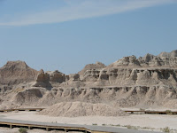
Badlands Scenic Loop. A few hours later into our trip the Badlands had become almost too much of the same thing; high, wind-carved cathedrals the color of bone. Voracious wind-- if we had stood in one spot long enough we would have been ground down, ourselves; chewed and striated by the hot harsh wind that probably killed cowboys once upon a time.

In one particular spot the limestone is the color of pink cotton candy, in another the color of a bright banana peel; the ancient sediment spun with geologic anomalies. We munched a buffalo hotdog on our drive out of the canyons.

From Badlands to Black Hills

And just as suddenly as we were overtaken by the strange Badlands, we were overcome by Black Hills. The South Dakota Black Hills are home to log cabins and cheap beef dinners. The area is thankfully unpretentious, comfortable in the visual riches they have to offer and not at all disposed to waging commercial competition for attention.

We avoided the pricey fee for going all the way into Crazy Horse, we took pictures from the road. The carving is immense, much bigger than the President’s heads on Mount Rushmore. The park fee goes toward supporting the epic carving project, but we were pretty wrung out on sight-seeing funds by the time we made it to this point. If you are interested in the history, pay the park fee and enjoy the interpretive center, otherwise there are good photo opps just outside the park gates.

South of Crazy Horse, outside Custer, SD we rented a small one-room log cabin. Owned and 
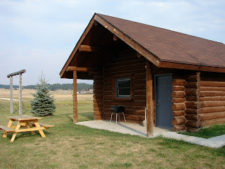
operated by a log home construction company the cabin was outfitted with all the modern conveniences. It cost us just over $100 for the night, less than a decent hotel and it was loaded with character, not to mention the perfect ambience in which to experience the South Dakota wilderness. If we had had more time we would have stayed longer and used the outdoor fire ring and fishing hole and spent an evening taking in the light show of a wide open night sky.

Our 
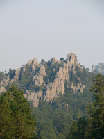
best driving tip of the trip was for Needles Scenic drive- a two to three hour drive through the best hidden twists and turns of the Black Hills. The drive, we cut it short by taking a short cut, really offers the best views of notable Black Hills peaks: Cathedral Spires and the Needles, both dramatic upright spikes of granite that scream ancient earth movement, looking thrust upright in a violent once-upon-a-time collision of tectonic plates or glacial tsunami. You can find Needles Drive not far from Crazy Horse. Follow routes 16A and 87. If you have a detailed map you can also cut the drive short if you need to; we did.

Our other “best of” recommendation was the dinner tip. In little downtown Hill City, just north of Custer, the Alpine Inn delivers a rare specialty: filet mignon dinner with all the trappings for $9.95 (no, not a typo). You can choose a smaller filet for $7.95, but we were hungry and totally taking advantage of the opportunity. Our total bill (for two) came to just under $30 and that with a glass of wine each added to the special. Do not expect options. This is the meal they serve every night, all year long.

Head West, young woman and man.

Thursday, February 21, 2008

Driving I-95 from Richmond to New York and Boston

Interstate 95 along the eastern corridor, particularly that stretch of tar between Richmond Virginia and Boston (the Megalopolis), has earned a reputation as a treacherous drive. Despite its teeth, millions of travelers hit this roadway everyday. I've been among them at various times of the year over the last 15 years. I've tackled 95 during rain and snow, during daylight hours, during nighttime, summer, winter, spring and fall, and holidays, weekends and weekdays.

I've found the absolute best time to challenge I-95 between Richmond and New York City, either north or southbound, is during the middle of the night. Again after years of being stung by traffic jams, bottlenecks and absurd congestion I far prefer this alternative. Nighttime driving along 95 is no desolate drive, you'll be surprised how many travelers opt for this time of day to make the pilgrimage north or south along infamous I-95. Rest areas are well lit and travelers are moving about.

Rest Areas and Full Service Travel Centers: In Maryland (Chesapeake House and Maryland House) and along the Jersey Turnpike the service centers are open, though many of the restaurants in them shut down around midnight. Although I was surprised this past Christmas to find a Starbucks open in a New Jersey travel center. Apparently they do this on the weekends--stay open later possibly even all night. You'll even find that many of the full service tourist centers have added WiFi services, so if you need to log on to your laptop you'll have little problem finding a hotspot.

You'll find that the major metro regions -- Baltimore and DC I'm thinking of particularly-- provide beltways around the areas and once upon a time I would have opted to drive those, but in recent years I've discovered that I have less traffic jams when I just follow I-95 signs straight through. In Baltimore this means you follow the highway through the Fort McHenry Tunnel that literally puts you underneath Baltimore Harbor. In New York City straight along I-95 carries you up and over the George Washington Bridge. Traveling southbound you'll get a view of the NYC skyline if you glance to your left; northbound you'll glance right. Beware: I've nearly be sideswiped taking in the skyline at night with a carefree glance. I reiterate: there is still a significant traffic volume through the major metro areas even at midnight and later.

How to drive on I-95: When you hit New York City and New Jersey yu better be alert and ready to drive with a mix of defensiveness and aggressiveness. Especially passing through NYC I-95 lanes are narrow and rough, concrete barriers allow little leeway for mistakes and you pass literally up underneath the city, lots of very tight, dark and rutted underpasses and drivers are confident and even aggressive--you must be a sure-footed driver. I actually consider this type of driving not unlike a sporting event--long-distance driving is not to be taken lightly and you really msut be mentally and physically prepared. Sound silly? Not if you've ever done this drive alone and in the middle of night. I've been nearly purposely run off the road by a trucker, I've seen a car in front of me have a major tire blow, I've been a passenger when a flatbed truck lost a stack of huge tires into our travel lane, and I've seen a car come sailing over a concrete barrier from opposing lanes and land behind me in oncoming traffic. Be alert and ready for anything.

Tolls: This stretch of I-95 is dotted with tolls. Northbound travelers pay more than southbound--no charge for GWBridge southbound. I think my latest calculations put a northbound toll total at around $27 between Richmond and NYC, so make sure you have cash. Frequent travelers along this route have E-Z Passes and you'll have to pay extra attention when coming up on the toll centers--some lanes are reserved for E-Z Pass holders only and do not take cash--so look for cash or combo lanes. And pay close attention to the traffic merges when coming out of the booths--where lanes have expanded for tolls they do the inverse--you'll lose lanes quickly and discover you merge with really fast moving traffic really quickly if you're not watching the road ahead.

Resources for Driving I-95:

Outside of a good road map a few other relevant resources include the NJ Turnpike Authority. The Visitors section of the NJTA website provides maps, traffic conditions and locations for service centers.

The Maryland Dept of Transportation website is ugly and not user-friendly so I'm not linking to it--useless unless you'd like to pick through PDF files and miniscule font. This needs a serious update!

Virginia DOT provides a pretty good index of links to a wide range of travel info that may help getting along the I-95 corridor in VA.

happy trails.

Buy a Road Map that Works

In the beginning there were no maps. Explorers set out to survey, sketch, and otherwise render their world. But we no longer have to set out with compass and survey equipment and pack animals. I criss-crossed the U.S. by car in 2007 with a travel nurse and a cat. Our most critical travel item was our road map. It is not one of those dinky ones, no abridged version. It features big pages full of state maps and accompanying pages with blow-ups of major metro areas (a critical feature). It also highlights national and state parks and makes a pretty accurate attempt to even show the actual exit numbers on the major highways.

For a road map with all that plus- you should shop for the ones that offer abbreviated state guides, trivia, and especially interesting the lists of must-see sites and places to eat in each state.